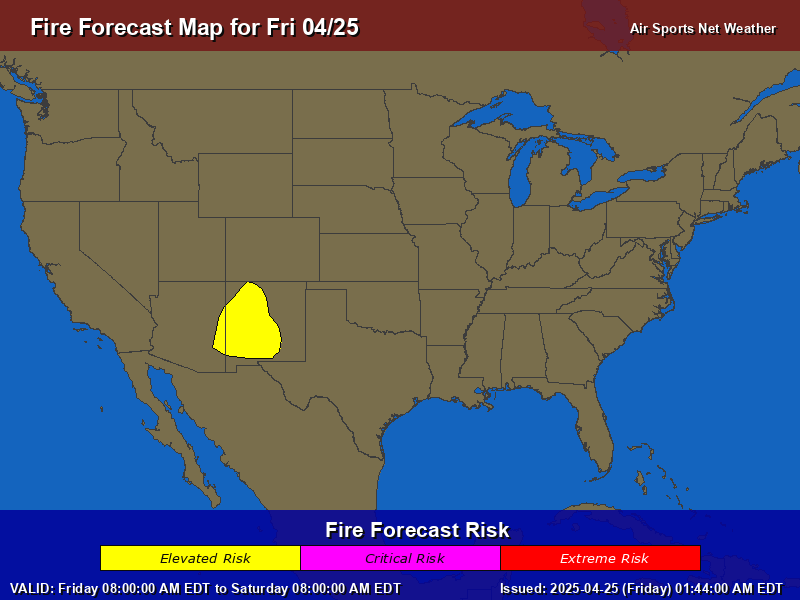
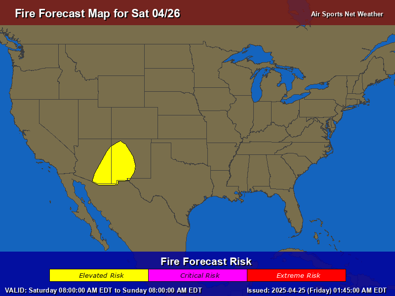
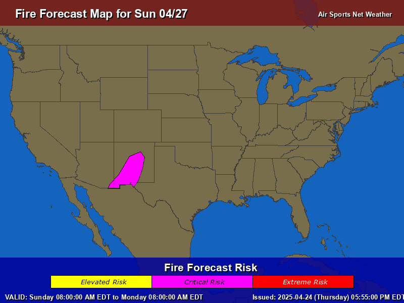
...CRITICAL FIRE WEATHER AREA FOR PARTS OF THE SOUTHWEST INTO THE SOUTHERN HIGH PLAINS...
...Synopsis... A northern Plains upper trough will move into the Upper Midwest today. A surface trough/cold front will move south and east. Deepening surface lows are expected in the Upper Midwest as well as the southern High Plains.
...Southwest into Southern Plains... As the trough moves north of the area, some extension of moderate mid-level wind will be present across the southern Rockies. A lee surface low is forecast to develop in the Texas Panhandle. These features will combine to promote surface winds around 20 mph over a broad area. RH could be very low in some places (5-10%), though 10-20% will be more common. Critical fire weather will occur for a several hours across parts of the Southwest into West Texas.
...South Dakota/Nebraska... Strong, gusty surface winds are expected behind the cold front. Winds of 15-25 mph appear possible. Cooling behind the front should lag in part due to a downslope component of the wind off the High Plains and mid-level drying allowing surface heating to occur. This should allow RH to fall to 15-25%. Drought impacted grasses will promote an elevated risk of fire ignition/spread.
..Wendt.. 04/13/2025
General Precautions for Fire Weather
Stay Informed: Monitor weather forecasts and fire warnings from official sources like [Local Fire Department, National Weather Service, etc. Have a battery-powered radio in case of power outages.
Be Aware of Your Surroundings: Pay close attention to your surroundings and be aware of any signs of fire, such as smoke or unusual fire behavior.
Be Ready to Evacuate
Prepare a "Go Bag": Have a readily accessible bag with essential items in case of evacuation, including:
Water
Non-perishable food
First-aid kit
Medications
Flashlight with extra batteries
Important documents (copies)
Clothing for all weather conditions
Cell phone and charger
Pet supplies (if applicable)
Be Prepared
Create a Wildfire Action Plan: Discuss a wildfire action plan with your family, including evacuation routes and meeting points. Practice your plan regularly.
Prepare your Home
Maintain Your Property:
Clear brush and debris around your home.
Keep lawns and vegetation trimmed.
Ensure your address is clearly visible from the street.
Inspect and maintain outdoor equipment (mowers, chainsaws, etc.) to prevent sparks.
Avoid Activities that Could Spark a Fire:
Refrain from open burning, including campfires and backyard fires.
Be extremely careful with smoking materials.
Avoid using fireworks.
Be cautious when operating machinery that could produce sparks, especially in dry grass or brush.
Ensure vehicles are in good working order, with no dragging parts that could create sparks.
If a Wildfire Threatens Your Area:
Evacuate Immediately: If you are advised to evacuate, do so immediately. Do not wait until the last minute.
Follow Evacuation Routes: Follow designated evacuation routes and do not take shortcuts.
Stay Informed: Listen to official sources for updates and instructions.
If Trapped: If you cannot evacuate, seek shelter in a sturdy building away from vegetation. Close all doors and windows and stay inside until it is safe to leave.
Remember: Wildfires can spread quickly and unexpectedly. Being prepared and taking precautions can significantly reduce your risk. Your safety is your responsibility.