Grand Forks, North Dakota Weather
Issued: 6:46 pm CST Nov 24, 2024 Latitude: 47.9252568 Longitude: -97.0328547 View on Google Maps
|
|
|
|
|
|
|
|
|
|
 |
 |
|
 |
|
 |
|
|
| Low: °F |
High: °F |
High: °F |
High: °F |
High: °F |
High: °F |
High: °F |
High: °F |
| Low: °F |
Low: °F |
Low: °F |
Low: °F |
Low: °F |
Low: °F |
|
| Snow |
Partly Sunny |
Partly Sunny |
Mostly Cloudy |
Snow |
Mostly Sunny |
Snow |
Partly Sunny |
Current Conditions at
GRAND FORKS INTL - (KGFK)
28°
Cloudy
as of 7:53 PM CST
Rel. Humidity: 86%
Dew Point: 25°F
Visibility: 10 Miles
Pressure: 30.01 in.
Flight Rule: MVFR
Wind Data
8 MPH
330° Northwest
Cloud Level(s): Solid Overcast at 1000ft
Current Conditions at
GRAND FORKS AFB - (KRDR)
Cloudy
as of 8:25 PM CST
Rel. Humidity: 79%
Dew Point: 21°F
Visibility: 10 Miles
Pressure: 30.01 in.
Flight Rule: MVFR
Wind Data
16 MPH
Gust: 22 MPH
320° Northwest
Cloud Level(s): Broken at 1000ft, Solid Overcast at 1500ft
Current Conditions at
CROOKSTON MUNICIPAL FIELD - (KCKN)
28°
Cloudy
as of 8:15 PM CST
Rel. Humidity: 92%
Dew Point: 27°F
Visibility: 10 Miles
Pressure: 30.00 in.
Flight Rule: VFR
Wind Data
8 MPH
320° Northwest
Current Conditions at
THIEF RIVER FALLS - (KTVF)
28°
Cloudy
as of 7:56 PM CST
Rel. Humidity: 92%
Dew Point: 27°F
Visibility: 10 Miles
Pressure: 29.98 in.
Flight Rule: MVFR
Cloud Level(s): Solid Overcast at 1400ft
|
Tonight... A 20 percent chance of snow before 10pm. Cloudy, then gradually becoming partly cloudy, with a low around 12. West northwest wind 9 to 11 mph, with gusts as high as 20 mph. |
|
|
Monday... Partly sunny, with a high near 20. West wind 10 to 16 mph, with gusts as high as 28 mph. |
|
 |
Monday Night... Partly cloudy, with a low around 8. West northwest wind 6 to 13 mph, with gusts as high as 22 mph. |
|
|
Tuesday... Partly sunny, with a high near 19. West northwest wind 3 to 6 mph. |
|
 |
Tuesday Night... A 30 percent chance of snow, mainly before midnight. Mostly cloudy, with a low around 12. Calm wind becoming north northwest around 5 mph after midnight. |
|
|
Wednesday... Mostly cloudy, with a high near 20. North northwest wind around 6 mph. |
|
|
Wednesday Night... A 20 percent chance of snow. Mostly cloudy, with a low around 7. West northwest wind 3 to 7 mph. |
|
|
Thanksgiving Day... A 20 percent chance of snow after noon. Mostly cloudy, with a high near 15. West northwest wind 7 to 14 mph, with gusts as high as 23 mph. |
|
|
Thursday Night... A 20 percent chance of snow before midnight. Mostly cloudy, with a low around -1. West northwest wind 10 to 13 mph, with gusts as high as 22 mph. |
|
|
Friday... Mostly sunny, with a high near 8. Northwest wind around 10 mph, with gusts as high as 18 mph. |
|
|
Friday Night... A 20 percent chance of snow. Mostly cloudy, with a low around -1. Northwest wind 7 to 9 mph. |
|
|
Saturday... A 20 percent chance of snow. Partly sunny, with a high near 10. Northwest wind 9 to 11 mph, with gusts as high as 21 mph. |
|
 |
Saturday Night... Mostly cloudy, with a low around -2. Northwest wind around 10 mph, with gusts as high as 18 mph. |
|
|
Sunday... Partly sunny, with a high near 10. Northwest wind around 11 mph, with gusts as high as 20 mph. |
|
Current Radar Image
Sun Almanac for Grand Forks, North Dakota
Sunrise: 07:48 AM
Sunset: 4:42 PM
Civil Sunrise:07:14 AM
Civil Sunset: 5:16 PM
Nautical Sunrise: 06:35 AM
Nautical Sunset: 5:55 PM
Astro Sunrise: 05:58 AM
Astro Sunset: 6:32 PM
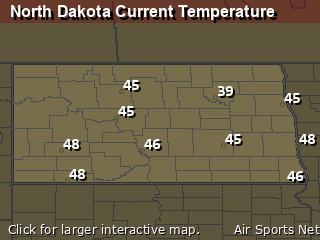
North Dakota's Current Temperatures
 North Dakota's Satellite Image
 North Dakota's Current Wind Direction
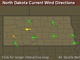
| National Summary |
of upper and lower values of current conditions amongst 6845 locations
in the contiguous United States |
|
High
Temp |
77° |
Keathley C 875, Louisiana
|
|
Low
Temp |
3° |
Cutbank, Montana
and 3 other locations
|
|
Wind
Speed |
38mph |
Salida Mountain, Colorado
|
|
Wind
Gust |
49mph |
Salida Mountain, Colorado
|
|
Wind
Chill |
-13° |
Plentywood, Montana
|
|
High
Pressure |
30.22Hg |
Malta, Montana
and 3 other locations
|
|
Low
Pressure |
29.38Hg |
Frenchville, Maine
|
|
| # Locations Reporting Snow |
35 |
|
| # Locations Reporting Rain |
36 |
|
| # Locations Reporting Fog |
2 |
|
| Average Temperature in the Contiguous USA |
46° |
|
Any use of the information on this page is at your own risk. This information should not be relied upon in life-threatening situations, potential financial loss situations or in lieu of any officially disseminated information. Visit the
National Weather Service for official information.


