Clovis, New Mexico Weather
No Watches or Warnings for Clovis
Issued: 3:08 pm MDT Apr 2, 2025 Latitude: 34.4047987 Longitude: -103.2052272 View on Google Maps
|
|
|
|
|
|
|
|
|
|
 |
 |
 |
 |
 |
|
|
|
| High: °F |
Low: °F |
High: °F |
High: °F |
High: °F |
High: °F |
High: °F |
High: °F |
| Low: °F |
Low: °F |
Low: °F |
Low: °F |
Low: °F |
|
| Partly Sunny |
Rain |
Sunny |
Rain |
Blowing Snow |
Sunny |
Sunny |
Sunny |
Current Conditions at
CANNON AFB - (KCVS)
61°
Mostly Cloudy
as of 2:55 PM MDST
Rel. Humidity: 17%
Dew Point: 16°F
Visibility: 10 Miles
Pressure: 29.70 in.
Flight Rule: VFR
Wind Data
16 MPH
Gust: 30 MPH
290° West
Cloud Level(s): Broken at 8500ft, Broken at 11000ft
Current Conditions at
CLOVIS - (KCVN)
61°
Clear
as of 2:56 PM MDST
Rel. Humidity: 14%
Dew Point: 12°F
Visibility: 10 Miles
Pressure: 29.71 in.
Flight Rule: VFR
Cloud Level(s): Clear
Current Conditions at
TUCUMCARI - (KTCC)
57°
Clear
as of 2:53 PM MDST
Rel. Humidity: 19%
Dew Point: 16°F
Visibility: 10 Miles
Pressure: 29.65 in.
Flight Rule: VFR
Wind Data
17 MPH
Gust: 28 MPH
240° Southwest
Cloud Level(s): Clear
Current Conditions at
PLAINVIEW - (KPVW)
66°
Clear
as of 4:10 PM CDST
Rel. Humidity: 11%
Dew Point: 10°F
Visibility: 10 Miles
Pressure: 29.67 in.
Flight Rule: VFR
Wind Data
21 MPH
Gust: 26 MPH
260° West
Cloud Level(s): Clear
|
This Afternoon... Partly sunny, with a high near 61. Southwest wind around 20 mph. |
|
|
Tonight... A chance of sprinkles before 9pm, then a slight chance of showers after 9pm. Mostly cloudy, with a low around 40. Southwest wind 10 to 15 mph becoming southeast after midnight. Chance of precipitation is 20%. |
|
|
Thursday... Sunny, with a high near 65. Southwest wind 10 to 20 mph. |
|
 |
Thursday Night... Showers likely, mainly after midnight. Mostly cloudy, with a low around 39. Southwest wind 15 to 20 mph becoming south 5 to 10 mph after midnight. Chance of precipitation is 70%. |
|
|
Friday... Showers. High near 53. East wind 5 to 15 mph. Chance of precipitation is 80%. |
|
 |
Friday Night... Showers likely and possibly a thunderstorm before midnight, then showers between midnight and 3am, then showers and possibly a thunderstorm after 3am. Low around 32. Breezy. Chance of precipitation is 90%. |
|
|
Saturday... Snow showers, possibly mixed with rain. Areas of blowing snow. High near 37. Breezy. Chance of precipitation is 90%. |
|
 |
Saturday Night... A 40 percent chance of snow showers before midnight. Mostly cloudy, with a low around 21. |
|
|
Sunday... Sunny, with a high near 48. |
|
 |
Sunday Night... Mostly clear, with a low around 28. |
|
|
Monday... Sunny, with a high near 63. |
|
|
Monday Night... Mostly clear, with a low around 35. |
|
|
Tuesday... Sunny, with a high near 73. |
|
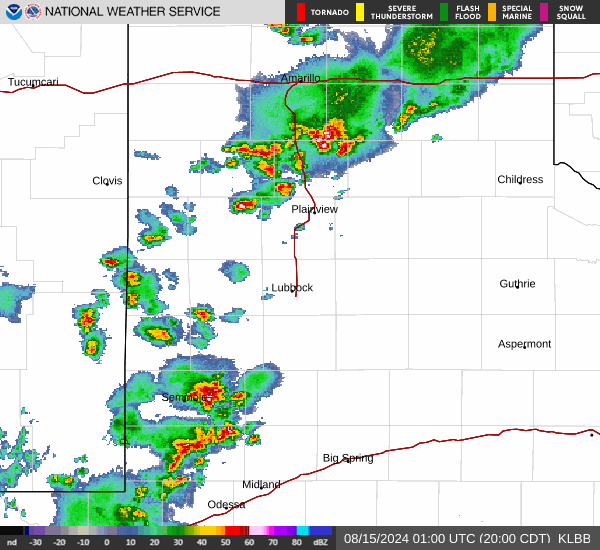
Current Radar Image
Sun Almanac for Clovis, New Mexico
Sunrise: 06:38 AM
Sunset: 7:15 PM
Civil Sunrise:06:12 AM
Civil Sunset: 7:40 PM
Nautical Sunrise: 05:43 AM
Nautical Sunset: 8:10 PM
Astro Sunrise: 05:12 AM
Astro Sunset: 8:40 PM
New Mexico's Current Temperatures
 New Mexico's Satellite Image
 New Mexico's Current Wind Direction
| National Summary |
of upper and lower values of current conditions amongst 7030 locations
in the contiguous United States |
|
High
Temp |
104° |
Laredo AFB, Texas
|
|
Low
Temp |
14° |
Dakota Hill, Colorado
and 2 other locations
|
|
Wind
Speed |
36mph |
Edgar County Arpt, Illinois
and 1 other location
|
|
Wind
Gust |
53mph |
Waterloo, Iowa
and 2 other locations
|
|
Wind
Chill |
-3° |
Salida Mountain, Colorado
|
|
Heat
Index |
109° |
Falfurrias, Texas
and 1 other location
|
|
High
Pressure |
30.55Hg |
Provincetown, Massachusetts
|
|
Low
Pressure |
29.20Hg |
Owatonna, Minnesota
|
|
| # Locations Reporting Snow |
87 |
|
| # Locations Reporting Rain |
121 |
|
| # Locations Reporting Thunderstorms / Lightning |
23 |
|
| # Locations Reporting Fog |
18 |
|
| Average Temperature in the Contiguous USA |
60° |
|
Any use of the information on this page is at your own risk. This information should not be relied upon in life-threatening situations, potential financial loss situations or in lieu of any officially disseminated information. Visit the
National Weather Service for official information.