Walts Corner, Colorado Weather
Current Conditions at
TRINIDAD - (KTAD)
39°
Cloudy
as of 8:54 AM MDST
Rel. Humidity: 55%
Dew Point: 25°F
Visibility: 10 Miles
Pressure: 30.62 in.
Flight Rule: VFR
Wind Data
8 MPH
030° Northeast
Cloud Level(s): Solid Overcast at 3900ft
Current Conditions at
RATON AIRPORT - (KRTN)
Cloudy
as of 8:53 AM MDST
Rel. Humidity: 51%
Dew Point: 23°F
Visibility: 10 Miles
Pressure: 30.56 in.
Flight Rule: VFR
Wind Data
15 MPH
020° North
Cloud Level(s): Solid Overcast at 4600ft
Current Conditions at
LA JUNTA - (KLHX)
Cloudy
as of 8:53 AM MDST
Rel. Humidity: 41%
Dew Point: 18°F
Visibility: 10 Miles
Pressure: 30.66 in.
Flight Rule: VFR
Wind Data
14 MPH
060° Northeast
Cloud Level(s): Solid Overcast at 5500ft
Current Conditions at
SPRINGFIELD - (KSPD)
Mostly Cloudy
as of 8:56 AM MDST
Rel. Humidity: 41%
Dew Point: 18°F
Pressure: 30.61 in.
Wind Data
22 MPH
030° Northeast
Moon Almanac for Walts Corner, Colorado
Moon Phase: Waxing Gibbous
Moon Illumination: 70%
Moon Age: 9.31 Days
Moon is currently below the horizon
Distance from Moon to Earth: 229,959 miles
Upcoming Lunar Events for
Walts Corner: |
| Next Event | Event Time | Illum |
|
|
|
| Moonrise: | 03:48 pm Fri | 72.0% |
| High Moon: | 11:16 pm Fri | 75.0% |
| Moonset: | 06:33 am Sat | 77.8% |
 | New Moon: Wed Mar 18 |
 | First Quarter: Wed Mar 25 |
 | Full Moon: Wed Apr 1 |
 | Last Quarter: Fri Apr 10 |
| New Moon: Fri Apr 17 |
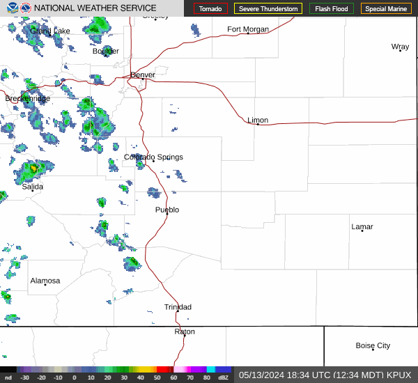
Current Radar Image
| Colorado State Summary |
of upper and lower values of current conditions amongst 63 locations
in Colorado |
|
High
Temp |
55° |
Grand Junction
|
|
Low
Temp |
23° |
Salida Mountain
and 1 other location
|
|
Wind
Speed |
22mph |
Springfield
|
|
Wind
Gust |
25mph |
Harriet-Alexander Field
|
|
|
|
High
Pressure |
30.73Hg |
Oscar Madis
|
|
Low
Pressure |
30.29Hg |
Cortez
|
|
| Average temperature in Colorado |
38° |
|
| # Locations Reporting Snow |
2 |
|
# Locations Reporting LIFR
(Low Instrument Flight Rules) |
3 |
|
# Locations Reporting MVFR
(Marginal Visual Flight Rules) |
5 |
|
# Locations Reporting VFR
(Visual Flight Rules) |
55 |
|
Colorado's Current Temperatures
 Colorado's Satellite Image
 Colorado's Current Wind Direction
| National Summary |
of upper and lower values of current conditions amongst 5453 locations
in the contiguous United States |
|
High
Temp |
82° |
Miss Canyan 807, Louisiana
|
|
Low
Temp |
-31° |
Jesup-Wayne Cty A/P, Georgia
|
|
Wind
Speed |
40mph |
Lawton Municipalcipal, Oklahoma
|
|
Wind
Gust |
58mph |
Lawton Municipalcipal, Oklahoma
|
|
Wind
Chill |
-9° |
Robertson Field, North Dakota
and 1 other location
|
|
High
Pressure |
30.74Hg |
Mercer Cnty Reg A/P, North Dakota
|
|
Low
Pressure |
29.82Hg |
Imperial, California
|
|
| # Locations Reporting Snow |
27 |
|
| # Locations Reporting Rain |
20 |
|
| # Locations Reporting Thunderstorms / Lightning |
1 |
|
| # Locations Reporting Fog |
4 |
|
| Average Temperature in the Contiguous USA |
48° |
|
Any use of the information on this page is at your own risk. This information should not be relied upon in life-threatening situations, potential financial loss situations or in lieu of any officially disseminated information. Visit the
National Weather Service for official information.