| your sport, your way | ||||
 |  |  |  |  |
|

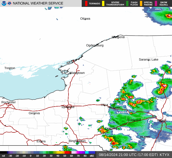
| Today | Tonight | Thursday | Friday | Saturday | Sunday | Monday | Tuesday |
 |
 |
 |
 |
 |
 |
|
|
| High: 17°F | Low: -2°F | High: 29°F | High: 23°F | High: 25°F | High: 28°F | High: 25°F | High: 24°F |
| Low: 19°F | Low: 12°F | Low: 14°F | Low: 6°F | Low: 7°F | |||
| Mostly Sunny | Increasing Clouds | Freezing Rain & Snow | Snow | Partly Sunny | Snow | Mostly Sunny | Partly Sunny |

|
Today... Mostly sunny, with a high near 17. Wind chill values as low as -20. Northwest wind around 6 mph. |
|
Tonight... Increasing clouds, with a low around -2. Light and variable wind. |
|
Thursday... Snow, possibly mixed with sleet before 3pm, then snow, possibly mixed with freezing rain between 3pm and 4pm, then freezing rain likely after 4pm. The snow could be heavy at times. High near 29. Wind chill values as low as -3. South wind 5 to 7 mph, with gusts as high as 20 mph. Chance of precipitation is 100%. New ice accumulation of less than a 0.1 of an inch possible. New snow and sleet accumulation of 1 to 3 inches possible. |
 |
Thursday Night... A chance of drizzle or freezing rain before 7pm, then a chance of drizzle, snow showers, and freezing rain between 7pm and 10pm, then a chance of snow showers after 10pm. Mostly cloudy, with a low around 19. West wind 7 to 15 mph, with gusts as high as 31 mph. Chance of precipitation is 50%. New snow accumulation of 1 to 2 inches possible. |
|
Friday... A chance of snow showers, mainly before 1pm. Partly sunny, with a high near 23. West wind 14 to 16 mph, with gusts as high as 32 mph. Chance of precipitation is 30%. |
|
Friday Night... Mostly cloudy, with a low around 12. |
|
Saturday... Partly sunny, with a high near 25. |
 |
Saturday Night... Snow. Low around 14. Chance of precipitation is 90%. |
|
Sunday... A chance of snow before 1pm. Mostly cloudy, with a high near 28. Chance of precipitation is 40%. |
|
Sunday Night... Mostly cloudy, with a low around 6. |
|
Monday... Mostly sunny, with a high near 25. |
 |
Monday Night... Partly cloudy, with a low around 7. |
|
Tuesday... Partly sunny, with a high near 24. |