Minnehaha, New York Weather
Issued: 6:37 am EST Feb 5, 2025 Latitude: 43.6617349 Longitude: -75.0679504 View on Google Maps
|
|
|
|
|
|
|
|
|
|
 |
 |
 |
 |
 |
 |
 |
 |
| High: °F |
Low: °F |
High: °F |
High: °F |
High: °F |
High: °F |
High: °F |
High: °F |
| Low: °F |
Low: °F |
Low: °F |
Low: °F |
Low: °F |
|
| Mostly Sunny |
Mostly Cloudy |
Freezing Rain & Snow |
Snow |
Partly Sunny |
Snow |
Mostly Cloudy |
Snow |
Current Conditions at
GRIFFISS AFB - (KRME)
9°
Partly Cloudy
as of 4:53 AM CST
Rel. Humidity: 71%
Dew Point: 1°F
Visibility: 10 Miles
Pressure: 30.41 in.
Flight Rule: VFR
Cloud Level(s): Scattered at 3600ft
Current Conditions at
FORT DRUM - (KGTB)
-9°
Clear
as of 5:55 AM EST
Rel. Humidity: 76%
Dew Point: -15°F
Visibility: 7 Miles
Pressure: 30.37 in.
Flight Rule: VFR
Wind Data
3 MPH
210° Southwest
Cloud Level(s): Clear
Current Conditions at
WATERTOWN - (KART)
-15°
Clear
as of 5:56 AM EST
Rel. Humidity: 68%
Dew Point: -22°F
Visibility: 10 Miles
Pressure: 30.43 in.
Flight Rule: VFR
Cloud Level(s): Clear
|
Today... Mostly sunny, with a high near 16. Wind chill values as low as -26. Light and variable wind becoming west around 6 mph in the afternoon. |
|
|
Tonight... Mostly cloudy, with a low around 0. Calm wind becoming southeast around 5 mph after midnight. |
|
|
Thursday... Snow before 2pm, then snow, possibly mixed with freezing rain between 2pm and 4pm, then freezing rain likely after 4pm. The snow could be heavy at times. High near 32. Wind chill values as low as zero. Southeast wind 8 to 11 mph, with gusts as high as 23 mph. Chance of precipitation is 100%. Little or no ice accumulation expected. New snow accumulation of 1 to 3 inches possible. |
|
 |
Thursday Night... A chance of drizzle or freezing rain before 7pm, then a chance of drizzle, snow showers, and freezing rain between 7pm and 10pm, then snow showers likely after 10pm. Cloudy, with a low around 19. West wind 9 to 15 mph, with gusts as high as 28 mph. Chance of precipitation is 70%. New snow accumulation of 1 to 2 inches possible. |
|
|
Friday... A chance of snow showers. Mostly cloudy, with a high near 23. West wind 13 to 16 mph, with gusts as high as 28 mph. Chance of precipitation is 40%. |
|
 |
Friday Night... A slight chance of snow showers. Mostly cloudy, with a low around 12. Chance of precipitation is 20%. |
|
|
Saturday... Partly sunny, with a high near 23. |
|
 |
Saturday Night... Snow. Low around 14. Chance of precipitation is 90%. |
|
|
Sunday... Snow likely before 1pm, then a chance of snow showers after 1pm. Mostly cloudy, with a high near 27. Chance of precipitation is 60%. |
|
|
Sunday Night... Mostly cloudy, with a low around 5. |
|
|
Monday... Mostly cloudy, with a high near 23. |
|
|
Monday Night... Mostly cloudy, with a low around 7. |
|
|
Tuesday... A chance of snow. Mostly cloudy, with a high near 22. Chance of precipitation is 30%. |
|
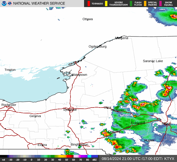
Current Radar Image
Sun Almanac for Minnehaha, New York
Sunrise: 07:12 AM
Sunset: 5:17 PM
Civil Sunrise:06:41 AM
Civil Sunset: 5:47 PM
Nautical Sunrise: 06:07 AM
Nautical Sunset: 6:21 PM
Astro Sunrise: 05:34 AM
Astro Sunset: 6:55 PM
New York's Current Temperatures
 New York's Satellite Image
 New York's Current Wind Direction
| National Summary |
of upper and lower values of current conditions amongst 7053 locations
in the contiguous United States |
|
High
Temp |
77° |
Keathley C 875, Louisiana
|
|
Low
Temp |
-15° |
Watertown, New York
and 1 other location
|
|
Wind
Speed |
44mph |
Evanston, Wyoming
|
|
Wind
Gust |
61mph |
Evanston, Wyoming
|
|
Wind
Chill |
-23° |
Frenchville, Maine
|
|
High
Pressure |
30.49Hg |
Menominee, Michigan
|
|
Low
Pressure |
29.33Hg |
Salmon, Idaho
|
|
| # Locations Reporting Snow |
58 |
|
| # Locations Reporting Rain |
34 |
|
| # Locations Reporting Fog |
100 |
|
| Average Temperature in the Contiguous USA |
33° |
|
Any use of the information on this page is at your own risk. This information should not be relied upon in life-threatening situations, potential financial loss situations or in lieu of any officially disseminated information. Visit the
National Weather Service for official information.