Lansing, New York Weather
Issued: 9:41 am EST Feb 5, 2025 Latitude: 43.4431242 Longitude: -76.4499387 View on Google Maps
|
|
|
|
|
|
|
|
|
|
 |
 |
 |
 |
 |
 |
|
|
| High: °F |
Low: °F |
High: °F |
High: °F |
High: °F |
High: °F |
High: °F |
High: °F |
| Low: °F |
Low: °F |
Low: °F |
Low: °F |
Low: °F |
|
| Mostly Cloudy |
Snow |
Rain, Snow, & Sleet |
Snow |
Snow |
Snow |
Mostly Cloudy |
Mostly Cloudy |
Current Conditions at
FULTON - (KFZY)
12°
Cloudy
as of 8:54 AM EST
Rel. Humidity: 72%
Dew Point: 5°F
Visibility: 10 Miles
Pressure: 30.46 in.
Flight Rule: VFR
Cloud Level(s): Solid Overcast at 4000ft
Current Conditions at
SYRACUSE - (KSYR)
16°
Mostly Cloudy
as of 8:54 AM EST
Rel. Humidity: 61%
Dew Point: 5°F
Visibility: 10 Miles
Pressure: 30.46 in.
Flight Rule: VFR
Cloud Level(s): Broken at 4000ft
Current Conditions at
WATERTOWN - (KART)
-6°
Clear
as of 8:56 AM EST
Rel. Humidity: 83%
Dew Point: -9°F
Visibility: 10 Miles
Pressure: 30.49 in.
Flight Rule: VFR
Cloud Level(s): Clear
Current Conditions at
GRIFFISS AFB - (KRME)
7°
Clear
as of 7:53 AM CST
Rel. Humidity: 77%
Dew Point: 1°F
Visibility: 10 Miles
Pressure: 30.48 in.
Flight Rule: VFR
Cloud Level(s): Clear
|
Today... Mostly cloudy, with a high near 20. Calm wind becoming west 5 to 8 mph in the afternoon. |
|
|
Tonight... A chance of snow after 5am. Mostly cloudy, with a low around 14. West wind 5 to 13 mph becoming southeast after midnight. Chance of precipitation is 30%. New snow accumulation of less than a half inch possible. |
|
|
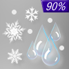
Thursday... Rain, snow, and sleet before 4pm, then a chance of rain between 4pm and 5pm, then a chance of rain and sleet after 5pm. High near 37. Southeast wind 11 to 17 mph. Chance of precipitation is 90%. New snow and sleet accumulation of 1 to 3 inches possible. |
|
 |
Thursday Night... A slight chance of rain before 11pm, then snow showers likely. Mostly cloudy, with a low around 24. Breezy, with a west wind 16 to 25 mph, with gusts as high as 40 mph. Chance of precipitation is 60%. New snow accumulation of less than a half inch possible. |
|
|
Friday... Snow showers, mainly before 3pm. High near 29. Breezy, with a west wind 20 to 25 mph, with gusts as high as 39 mph. Chance of precipitation is 80%. |
|
 |
Friday Night... Snow showers likely, mainly between 9pm and 4am. Mostly cloudy, with a low around 21. West wind 8 to 16 mph, with gusts as high as 26 mph. Chance of precipitation is 70%. |
|
|
Saturday... A chance of snow showers before 1pm. Mostly cloudy, with a high near 28. West wind around 6 mph becoming calm. Chance of precipitation is 40%. |
|
 |
Saturday Night... Snow. Low around 22. East wind around 7 mph becoming south after midnight. Chance of precipitation is 100%. |
|
|
Sunday... A chance of snow showers. Mostly cloudy, with a high near 29. Chance of precipitation is 50%. |
|
|
Sunday Night... A chance of snow showers. Mostly cloudy, with a low around 19. Chance of precipitation is 50%. |
|
|
Monday... Mostly cloudy, with a high near 28. |
|
 |
Monday Night... Mostly cloudy, with a low around 17. |
|
|
Tuesday... Mostly cloudy, with a high near 25. |
|
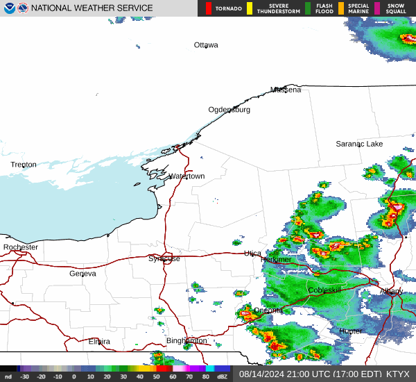
Current Radar Image
Sun Almanac for Lansing, New York
Sunrise: 07:17 AM
Sunset: 5:23 PM
Civil Sunrise:06:47 AM
Civil Sunset: 5:53 PM
Nautical Sunrise: 06:13 AM
Nautical Sunset: 6:27 PM
Astro Sunrise: 05:39 AM
Astro Sunset: 7:00 PM
New York's Current Temperatures
 New York's Satellite Image
 New York's Current Wind Direction
| National Summary |
of upper and lower values of current conditions amongst 7111 locations
in the contiguous United States |
|
High
Temp |
79° |
Keathley C 875, Louisiana
|
|
Low
Temp |
-13° |
Foxtrot, Montana
|
|
Wind
Speed |
30mph |
Laramie, Wyoming
and 2 other locations
|
|
Wind
Gust |
46mph |
Elk Mountain, Wyoming
and 1 other location
|
|
Wind
Chill |
-29° |
Cutbank, Montana
|
|
High
Pressure |
30.51Hg |
Massena, New York
|
|
Low
Pressure |
29.49Hg |
Butte, Montana
|
|
| # Locations Reporting Snow |
58 |
|
| # Locations Reporting Rain |
40 |
|
| # Locations Reporting Fog |
69 |
|
| Average Temperature in the Contiguous USA |
35° |
|
Any use of the information on this page is at your own risk. This information should not be relied upon in life-threatening situations, potential financial loss situations or in lieu of any officially disseminated information. Visit the
National Weather Service for official information.