Forest Glen, New York Weather
Issued: 9:41 am EST Feb 5, 2025 Latitude: 42.7317259 Longitude: -78.8483664 View on Google Maps
|
|
|
|
|
|
|
|
|
|
 |
 |
 |
 |
 |
 |
|
 |
| High: °F |
Low: °F |
High: °F |
High: °F |
High: °F |
High: °F |
High: °F |
High: °F |
| Low: °F |
Low: °F |
Low: °F |
Low: °F |
Low: °F |
|
| Snow |
Snow |
Rain, Snow, & Sleet |
Partly Sunny |
Snow |
Snow |
Partly Sunny |
Mostly Cloudy |
Current Conditions at
BUFFALO - (KBUF)
19°
Cloudy
Light Snow
as of 8:54 AM EST
Rel. Humidity: 67%
Dew Point: 10°F
Visibility: 10 Miles
Pressure: 30.44 in.
Flight Rule: MVFR
Wind Data
7 MPH
240° Southwest
Cloud Level(s): Broken at 2300ft, Solid Overcast at 3300ft
Current Conditions at
NIAGARA FALLS - (KIAG)
21°
Cloudy
Light Snow
as of 9:22 AM EST
Rel. Humidity: 38%
Visibility: 5 Miles
Pressure: 30.45 in.
Flight Rule: MVFR
Wind Data
7 MPH
230° Southwest
Cloud Level(s): Broken at 2100ft, Solid Overcast at 3200ft
Current Conditions at
DUNKIRK - (KDKK)
21°
Partly Cloudy
as of 8:53 AM EST
Rel. Humidity: 67%
Dew Point: 12°F
Visibility: 10 Miles
Pressure: 30.46 in.
Flight Rule: VFR
Cloud Level(s): Scattered at 3400ft
Current Conditions at
WELLSVILLE MUNI - (KELZ)
14°
Mostly Cloudy
as of 9:23 AM EST
Rel. Humidity: 72%
Dew Point: 7°F
Visibility: 10 Miles
Pressure: 30.34 in.
Flight Rule: MVFR
Wind Data
5 MPH
320° Northwest
Cloud Level(s): Broken at 1700ft
|
Today... A slight chance of snow showers before 10am. Mostly cloudy, with a high near 24. South wind around 5 mph becoming calm in the morning. Chance of precipitation is 20%. |
|
|
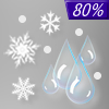
Tonight... Snow likely, mainly after 5am. Mostly cloudy, with a temperature falling to near 19 by 8pm, then rising to around 29 during the remainder of the night. East wind 6 to 14 mph becoming southeast after midnight. Chance of precipitation is 60%. New snow accumulation of less than a half inch possible. |
|
|
Thursday... Snow and sleet before 9am, then rain and sleet likely between 9am and 10am, then rain likely after 10am. High near 40. Breezy, with a southeast wind 15 to 23 mph becoming southwest in the afternoon. Chance of precipitation is 80%. New snow and sleet accumulation of less than a half inch possible. |
|
 |
Thursday Night... A slight chance of rain, snow showers, and sleet before 11pm, then a slight chance of snow showers after 3am. Mostly cloudy, with a low around 19. Breezy, with a southwest wind 21 to 28 mph, with gusts as high as 40 mph. Chance of precipitation is 20%. |
|
|
Friday... Partly sunny, with a high near 24. West wind 14 to 18 mph, with gusts as high as 30 mph. |
|
 |
Friday Night... Mostly cloudy, with a low around 16. West wind 5 to 10 mph. |
|
|
Saturday... A chance of snow after 1pm. Mostly cloudy, with a high near 32. Light and variable wind becoming east around 6 mph in the afternoon. Chance of precipitation is 50%. |
|
 |
Saturday Night... Snow. Low around 24. East wind 5 to 7 mph becoming light and variable. Chance of precipitation is 100%. |
|
|
Sunday... A chance of snow showers. Mostly cloudy, with a high near 29. Chance of precipitation is 40%. |
|
|
Sunday Night... Mostly cloudy, with a low around 18. |
|
|
Monday... Partly sunny, with a high near 27. |
|
|
Monday Night... Mostly cloudy, with a low around 14. |
|
|
Tuesday... Mostly cloudy, with a high near 26. |
|
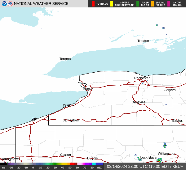
Current Radar Image
Sun Almanac for Forest Glen, New York
Sunrise: 07:25 AM
Sunset: 5:34 PM
Civil Sunrise:06:55 AM
Civil Sunset: 6:04 PM
Nautical Sunrise: 06:21 AM
Nautical Sunset: 6:37 PM
Astro Sunrise: 05:49 AM
Astro Sunset: 7:10 PM
New York's Current Temperatures
 New York's Satellite Image
 New York's Current Wind Direction
| National Summary |
of upper and lower values of current conditions amongst 7111 locations
in the contiguous United States |
|
High
Temp |
79° |
Keathley C 875, Louisiana
|
|
Low
Temp |
-13° |
Foxtrot, Montana
|
|
Wind
Speed |
33mph |
Elk Mountain, Wyoming
|
|
Wind
Gust |
47mph |
Salmon, Idaho
|
|
Wind
Chill |
-31° |
Cutbank, Montana
|
|
High
Pressure |
30.51Hg |
Massena, New York
|
|
Low
Pressure |
29.48Hg |
Mullan Pass, Idaho
and 1 other location
|
|
| # Locations Reporting Snow |
56 |
|
| # Locations Reporting Rain |
42 |
|
| # Locations Reporting Fog |
84 |
|
| Average Temperature in the Contiguous USA |
35° |
|
Any use of the information on this page is at your own risk. This information should not be relied upon in life-threatening situations, potential financial loss situations or in lieu of any officially disseminated information. Visit the
National Weather Service for official information.