
| your sport, your way | ||||
 |  |  |  |  |
|

| Today | Tonight | Thursday | Friday | Saturday | Sunday | Monday | Tuesday |
 |
 |
 |
 |
 |
 |
 |
 |
| High: 36°F | Low: 30°F | High: 55°F | High: 57°F | High: 41°F | High: 55°F | High: 39°F | High: 38°F |
| Low: 38°F | Low: 29°F | Low: 35°F | Low: 28°F | Low: 29°F | |||
| Rain | Rain & Sleet | Freezing Rain | Sunny | Freezing Rain & Snow | Mostly Sunny | Snow | Snow |


|
Today... A slight chance of rain after 1pm. Cloudy, with a high near 36. Calm wind. Chance of precipitation is 20%. |
|
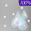
Tonight... Rain and sleet, possibly mixed with freezing rain before 11pm, then rain and sleet between 11pm and midnight, then rain and sleet, possibly mixed with freezing rain after midnight. Low around 30. Calm wind. Chance of precipitation is 100%. New ice accumulation of 0.1 to 0.2 of an inch possible. New sleet accumulation of less than a half inch possible. |
|
Thursday... Sleet, possibly mixed with freezing rain before 8am, then rain. High near 55. Light south wind increasing to 5 to 10 mph in the morning. Winds could gust as high as 21 mph. Chance of precipitation is 90%. Little or no ice accumulation expected. New sleet accumulation of less than a half inch possible. |
 |
Thursday Night... A slight chance of rain before 1am. Mostly cloudy, with a low around 38. Southwest wind around 6 mph becoming calm in the evening. Chance of precipitation is 20%. |
|
Friday... Sunny, with a high near 57. Calm wind becoming northwest around 5 mph. |
 |
Friday Night... A slight chance of rain between 1am and 4am, then a slight chance of snow after 4am. Mostly cloudy, with a low around 29. Chance of precipitation is 20%. |
|
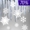
Saturday... A chance of freezing rain before 7am, then a chance of rain, snow, and freezing rain between 7am and 1pm, then rain likely after 1pm. Mostly cloudy, with a high near 41. Chance of precipitation is 70%. |
 |
Saturday Night... Rain likely, mainly before 1am. Mostly cloudy, with a low around 35. Chance of precipitation is 60%. |
|
Sunday... Mostly sunny, with a high near 55. |
 |
Sunday Night... Mostly cloudy, with a low around 28. |
|
Monday... A chance of snow. Partly sunny, with a high near 39. Chance of precipitation is 50%. |
|
Monday Night... A chance of snow. Mostly cloudy, with a low around 29. Chance of precipitation is 50%. |
|
Tuesday... Snow. High near 38. Chance of precipitation is 80%. |


