Aviation Weather Report for Kremmling/Mcelroy, Colorado
KREMM...      
WALTO...      
GRANB...      
Current Conditions at
KREMMLING, CO - (K20V)
39°
Cloudy
as of 12:35 AM MDST
Rel. Humidity: 27%
Dew Point: 9°F
Visibility: 10 Miles
Pressure: 29.60 in.
Flight Rule: VFR
Sun Almanac
Naut Sunrise:
5:49 AM
Civil Sunrise:
6:21 AM
Sunrise:
6:48 AM
Sunset:
7:30 PM
Civil Sunset:
7:57 PM
Naut Sunset:
8:30 PM
Wind Data
Calm
Cloud Level(s): Solid Overcast at 8500 ft
Colorado Weather Conditions
Change State/Region
Change Location in Colorado
Change Location By ICAO
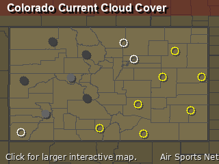
Colorado Cloud Cover

Aviation Weather Forecast at Kremmling/Mcelroy, Colorado
Station: K20V    North: 40.05    West: -106.37    Timezone: Mountain Daylight Saving Time    UTC: -6    Model: National Blend of Models - Aviation Format
 
DATETUESDAY
 APRIL 1  
WEDNESDAY
 APRIL 2  
THU
 
HOUR3:00 AM6:00 AM9:00 AMNOON3:00 PM6:00 PM9:00 PMMID NIGHT3:00 AM6:00 AM9:00 AMNOON3:00 PM6:00 PM9:00 PMMID NIGHT3:00 AM6:00 AM9:00 AMNOON3:00 PM6:00 PM
SKY Mostly Cloudy
Aviation Weather 81% Clouds
Mostly Cloudy
Aviation Weather 85% Clouds
Cloudy
Aviation Weather 95% Clouds
Cloudy
Aviation Weather 92% Clouds
Mostly Cloudy
Aviation Weather 83% Clouds
Cloudy
Aviation Weather 88% Clouds
Cloudy
Aviation Weather 88% Clouds
Mostly Cloudy
Aviation Weather 67% Clouds
Partly Cloudy
Aviation Weather 61% Clouds
Mostly Cloudy
Aviation Weather 65% Clouds
Mostly Cloudy
Aviation Weather 64% Clouds
Mostly Cloudy
Aviation Weather 65% Clouds
Partly Cloudy
Aviation Weather 62% Clouds
Partly Cloudy
Aviation Weather 61% Clouds
Partly Cloudy
Aviation Weather 47% Clouds
Partly Cloudy
Aviation Weather 55% Clouds
Mostly Cloudy
Aviation Weather 63% Clouds
Mostly Cloudy
Aviation Weather 78% Clouds
Cloudy
Aviation Weather 88% Clouds
Mostly Cloudy
Aviation Weather 84% Clouds
Mostly Cloudy
Aviation Weather 86% Clouds
Mostly Cloudy
Aviation Weather 82% Clouds
TEMP
(F)
36
TemperatureTemperatureTemperatureTemperatureTemperatureTemperatureTemperatureTemperature
33
TemperatureTemperatureTemperatureTemperatureTemperatureTemperatureTemperatureTemperature
34
TemperatureTemperatureTemperatureTemperatureTemperatureTemperatureTemperatureTemperature
36
TemperatureTemperatureTemperatureTemperatureTemperatureTemperatureTemperatureTemperature
36
TemperatureTemperatureTemperatureTemperatureTemperatureTemperatureTemperatureTemperature
33
TemperatureTemperatureTemperatureTemperatureTemperatureTemperatureTemperatureTemperature
27
TemperatureTemperatureTemperatureTemperatureTemperatureTemperatureTemperatureTemperature
24
TemperatureTemperatureTemperatureTemperatureTemperatureTemperatureTemperatureTemperature
22
TemperatureTemperatureTemperatureTemperatureTemperatureTemperatureTemperatureTemperature
20
TemperatureTemperatureTemperatureTemperatureTemperatureTemperatureTemperatureTemperature
26
TemperatureTemperatureTemperatureTemperatureTemperatureTemperatureTemperatureTemperature
33
TemperatureTemperatureTemperatureTemperatureTemperatureTemperatureTemperatureTemperature
35
TemperatureTemperatureTemperatureTemperatureTemperatureTemperatureTemperatureTemperature
34
TemperatureTemperatureTemperatureTemperatureTemperatureTemperatureTemperatureTemperature
24
TemperatureTemperatureTemperatureTemperatureTemperatureTemperatureTemperatureTemperature
19
TemperatureTemperatureTemperatureTemperatureTemperatureTemperatureTemperatureTemperature
17
TemperatureTemperatureTemperatureTemperatureTemperatureTemperatureTemperatureTemperature
16
TemperatureTemperatureTemperatureTemperatureTemperatureTemperatureTemperatureTemperature
24
TemperatureTemperatureTemperatureTemperatureTemperatureTemperatureTemperatureTemperature
34
TemperatureTemperatureTemperatureTemperatureTemperatureTemperatureTemperatureTemperature
37
TemperatureTemperatureTemperatureTemperatureTemperatureTemperatureTemperatureTemperature
35
TemperatureTemperatureTemperatureTemperatureTemperatureTemperatureTemperatureTemperature
WIND CHILL2925262828241916151219262931-----333432
WIND DIRECTION
(AZIMUTH)

Help

230
Wind Direction

240
Wind Direction

280
Wind Direction

270
Wind Direction

290
Wind Direction

290
Wind Direction

240
Wind Direction

250
Wind Direction

230
Wind Direction

270
Wind Direction

260
Wind Direction

270
Wind Direction

280
Wind Direction

290
Wind Direction


Wind Direction


Wind Direction


Wind Direction


Wind Direction


Wind Direction

70
Wind Direction

290
Wind Direction

290
Wind Direction
AVERAGE
WIND SPEEDS

(MPH)

Help
8
Wind SpeedWind SpeedWind SpeedWind SpeedWind SpeedWind SpeedWind SpeedWind Speed
9
Wind SpeedWind SpeedWind SpeedWind SpeedWind SpeedWind SpeedWind SpeedWind Speed
10
Wind SpeedWind SpeedWind SpeedWind SpeedWind SpeedWind SpeedWind SpeedWind Speed
10
Wind SpeedWind SpeedWind SpeedWind SpeedWind SpeedWind SpeedWind SpeedWind Speed
11
Wind SpeedWind SpeedWind SpeedWind SpeedWind SpeedWind SpeedWind SpeedWind Speed
10
Wind SpeedWind SpeedWind SpeedWind SpeedWind SpeedWind SpeedWind SpeedWind Speed
7
Wind SpeedWind SpeedWind SpeedWind SpeedWind SpeedWind SpeedWind SpeedWind Speed
6
Wind SpeedWind SpeedWind SpeedWind SpeedWind SpeedWind SpeedWind SpeedWind Speed
5
Wind SpeedWind SpeedWind SpeedWind SpeedWind SpeedWind SpeedWind SpeedWind Speed
5
Wind SpeedWind SpeedWind SpeedWind SpeedWind SpeedWind SpeedWind SpeedWind Speed
6
Wind SpeedWind SpeedWind SpeedWind SpeedWind SpeedWind SpeedWind SpeedWind Speed
8
Wind SpeedWind SpeedWind SpeedWind SpeedWind SpeedWind SpeedWind SpeedWind Speed
7
Wind SpeedWind SpeedWind SpeedWind SpeedWind SpeedWind SpeedWind SpeedWind Speed
3
Wind SpeedWind SpeedWind SpeedWind SpeedWind SpeedWind SpeedWind SpeedWind Speed
0
Wind SpeedWind SpeedWind SpeedWind SpeedWind SpeedWind SpeedWind SpeedWind Speed
0
Wind SpeedWind SpeedWind SpeedWind SpeedWind SpeedWind SpeedWind SpeedWind Speed
0
Wind SpeedWind SpeedWind SpeedWind SpeedWind SpeedWind SpeedWind SpeedWind Speed
0
Wind SpeedWind SpeedWind SpeedWind SpeedWind SpeedWind SpeedWind SpeedWind Speed
0
Wind SpeedWind SpeedWind SpeedWind SpeedWind SpeedWind SpeedWind SpeedWind Speed
2
Wind SpeedWind SpeedWind SpeedWind SpeedWind SpeedWind SpeedWind SpeedWind Speed
3
Wind SpeedWind SpeedWind SpeedWind SpeedWind SpeedWind SpeedWind SpeedWind Speed
3
Wind SpeedWind SpeedWind SpeedWind SpeedWind SpeedWind SpeedWind SpeedWind Speed
MAXIMUM
WIND GUST SPEEDS

(MPH)

Help
17
Wind Gust SpeedWind Gust SpeedWind Gust SpeedWind Gust SpeedWind Gust SpeedWind Gust SpeedWind Gust SpeedWind Gust Speed
18
Wind Gust SpeedWind Gust SpeedWind Gust SpeedWind Gust SpeedWind Gust SpeedWind Gust SpeedWind Gust SpeedWind Gust Speed
17
Wind Gust SpeedWind Gust SpeedWind Gust SpeedWind Gust SpeedWind Gust SpeedWind Gust SpeedWind Gust SpeedWind Gust Speed
17
Wind Gust SpeedWind Gust SpeedWind Gust SpeedWind Gust SpeedWind Gust SpeedWind Gust SpeedWind Gust SpeedWind Gust Speed
19
Wind Gust SpeedWind Gust SpeedWind Gust SpeedWind Gust SpeedWind Gust SpeedWind Gust SpeedWind Gust SpeedWind Gust Speed
19
Wind Gust SpeedWind Gust SpeedWind Gust SpeedWind Gust SpeedWind Gust SpeedWind Gust SpeedWind Gust SpeedWind Gust Speed
15
Wind Gust SpeedWind Gust SpeedWind Gust SpeedWind Gust SpeedWind Gust SpeedWind Gust SpeedWind Gust SpeedWind Gust Speed
13
Wind Gust SpeedWind Gust SpeedWind Gust SpeedWind Gust SpeedWind Gust SpeedWind Gust SpeedWind Gust SpeedWind Gust Speed
12
Wind Gust SpeedWind Gust SpeedWind Gust SpeedWind Gust SpeedWind Gust SpeedWind Gust SpeedWind Gust SpeedWind Gust Speed
11
Wind Gust SpeedWind Gust SpeedWind Gust SpeedWind Gust SpeedWind Gust SpeedWind Gust SpeedWind Gust SpeedWind Gust Speed
12
Wind Gust SpeedWind Gust SpeedWind Gust SpeedWind Gust SpeedWind Gust SpeedWind Gust SpeedWind Gust SpeedWind Gust Speed
14
Wind Gust SpeedWind Gust SpeedWind Gust SpeedWind Gust SpeedWind Gust SpeedWind Gust SpeedWind Gust SpeedWind Gust Speed
13
Wind Gust SpeedWind Gust SpeedWind Gust SpeedWind Gust SpeedWind Gust SpeedWind Gust SpeedWind Gust SpeedWind Gust Speed
9
Wind Gust SpeedWind Gust SpeedWind Gust SpeedWind Gust SpeedWind Gust SpeedWind Gust SpeedWind Gust SpeedWind Gust Speed
4
Wind Gust SpeedWind Gust SpeedWind Gust SpeedWind Gust SpeedWind Gust SpeedWind Gust SpeedWind Gust SpeedWind Gust Speed
4
Wind Gust SpeedWind Gust SpeedWind Gust SpeedWind Gust SpeedWind Gust SpeedWind Gust SpeedWind Gust SpeedWind Gust Speed
4
Wind Gust SpeedWind Gust SpeedWind Gust SpeedWind Gust SpeedWind Gust SpeedWind Gust SpeedWind Gust SpeedWind Gust Speed
4
Wind Gust SpeedWind Gust SpeedWind Gust SpeedWind Gust SpeedWind Gust SpeedWind Gust SpeedWind Gust SpeedWind Gust Speed
4
Wind Gust SpeedWind Gust SpeedWind Gust SpeedWind Gust SpeedWind Gust SpeedWind Gust SpeedWind Gust SpeedWind Gust Speed
7
Wind Gust SpeedWind Gust SpeedWind Gust SpeedWind Gust SpeedWind Gust SpeedWind Gust SpeedWind Gust SpeedWind Gust Speed
8
Wind Gust SpeedWind Gust SpeedWind Gust SpeedWind Gust SpeedWind Gust SpeedWind Gust SpeedWind Gust SpeedWind Gust Speed
8
Wind Gust SpeedWind Gust SpeedWind Gust SpeedWind Gust SpeedWind Gust SpeedWind Gust SpeedWind Gust SpeedWind Gust Speed
HOUR3:00 AM6:00 AM9:00 AMNOON3:00 PM6:00 PM9:00 PMMID NIGHT3:00 AM6:00 AM9:00 AMNOON3:00 PM6:00 PM9:00 PMMID NIGHT3:00 AM6:00 AM9:00 AMNOON3:00 PM6:00 PM
DATETUESDAY
 APRIL 1  
WEDNESDAY
 APRIL 2  
THU
 
HOUR3:00 AM6:00 AM9:00 AMNOON3:00 PM6:00 PM9:00 PMMID NIGHT3:00 AM6:00 AM9:00 AMNOON3:00 PM6:00 PM9:00 PMMID NIGHT3:00 AM6:00 AM9:00 AMNOON3:00 PM6:00 PM
CLOUD COVERAGE
%
81 85 95 92 83 88 88 67 61 65 64 65 62 61 47 55 63 78 88 84 86 82
CLOUD
BASE
@ 60%
COVERAGE
(AGL in
Feet)


Help

3500
Cloud Base % Coverage in Feet

4500
Cloud Base % Coverage in Feet

1800
Cloud Base % Coverage in Feet

3500
Cloud Base % Coverage in Feet

3500
Cloud Base % Coverage in Feet

3500
Cloud Base % Coverage in Feet

3500
Cloud Base % Coverage in Feet

2200
Cloud Base % Coverage in Feet

4500
Cloud Base % Coverage in Feet

4500
Cloud Base % Coverage in Feet

6000
Cloud Base % Coverage in Feet

10K
Cloud Base % Coverage in Feet

10K
Cloud Base % Coverage in Feet

10K
Cloud Base % Coverage in Feet

6000
Cloud Base % Coverage in Feet

6000
Cloud Base % Coverage in Feet

5000
Cloud Base % Coverage in Feet

2800
Cloud Base % Coverage in Feet
LOWEST
CLOUD
BASE
(AGL in
Feet)


Help

3100
Low Cloud Base in Feet

3100
Low Cloud Base in Feet

1400
Low Cloud Base in Feet

2700
Low Cloud Base in Feet

2100
Low Cloud Base in Feet

2100
Low Cloud Base in Feet

2400
Low Cloud Base in Feet

2200
Low Cloud Base in Feet

3100
Low Cloud Base in Feet

3100
Low Cloud Base in Feet

3600
Low Cloud Base in Feet

2800
Low Cloud Base in Feet

2800
Low Cloud Base in Feet

2500
Low Cloud Base in Feet

14K
Low Cloud Base in Feet

12K
Low Cloud Base in Feet

7000
Low Cloud Base in Feet

4600
Low Cloud Base in Feet

2700
Low Cloud Base in Feet

3300
Low Cloud Base in Feet

1400
Low Cloud Base in Feet

100
Low Cloud Base in Feet
VISIBILITY
(Miles)
6
VisibilityVisibilityVisibilityVisibilityVisibilityVisibilityVisibilityVisibility
9
VisibilityVisibilityVisibilityVisibilityVisibilityVisibilityVisibilityVisibility
3
VisibilityVisibilityVisibilityVisibilityVisibilityVisibilityVisibilityVisibility
10
VisibilityVisibilityVisibilityVisibilityVisibilityVisibilityVisibilityVisibility
7
VisibilityVisibilityVisibilityVisibilityVisibilityVisibilityVisibilityVisibility
7
VisibilityVisibilityVisibilityVisibilityVisibilityVisibilityVisibilityVisibility
5
VisibilityVisibilityVisibilityVisibilityVisibilityVisibilityVisibilityVisibility
5
VisibilityVisibilityVisibilityVisibilityVisibilityVisibilityVisibilityVisibility
10
VisibilityVisibilityVisibilityVisibilityVisibilityVisibilityVisibilityVisibility
10
VisibilityVisibilityVisibilityVisibilityVisibilityVisibilityVisibilityVisibility
10
VisibilityVisibilityVisibilityVisibilityVisibilityVisibilityVisibilityVisibility
10
VisibilityVisibilityVisibilityVisibilityVisibilityVisibilityVisibilityVisibility
10
VisibilityVisibilityVisibilityVisibilityVisibilityVisibilityVisibilityVisibility
10
VisibilityVisibilityVisibilityVisibilityVisibilityVisibilityVisibilityVisibility
10
VisibilityVisibilityVisibilityVisibilityVisibilityVisibilityVisibilityVisibility
10
VisibilityVisibilityVisibilityVisibilityVisibilityVisibilityVisibilityVisibility
10
VisibilityVisibilityVisibilityVisibilityVisibilityVisibilityVisibilityVisibility
10
VisibilityVisibilityVisibilityVisibilityVisibilityVisibilityVisibilityVisibility
10
VisibilityVisibilityVisibilityVisibilityVisibilityVisibilityVisibilityVisibility
10
VisibilityVisibilityVisibilityVisibilityVisibilityVisibilityVisibilityVisibility
10
VisibilityVisibilityVisibilityVisibilityVisibilityVisibilityVisibilityVisibility
5
VisibilityVisibilityVisibilityVisibilityVisibilityVisibilityVisibilityVisibility
FLIGHT RULE

Help
VFRVFRIFRMVFRMVFRMVFRMVFRMVFRVFRVFRVFRMVFRVFRVFRVFRVFRVFRVFRMVFRVFRMVFRLIFR
HOUR3:00 AM6:00 AM9:00 AMNOON3:00 PM6:00 PM9:00 PMMID NIGHT3:00 AM6:00 AM9:00 AMNOON3:00 PM6:00 PM9:00 PMMID NIGHT3:00 AM6:00 AM9:00 AMNOON3:00 PM6:00 PM
DATETUESDAY
 APRIL 1  
WEDNESDAY
 APRIL 2  
THU
 
HOUR3:00 AM6:00 AM9:00 AMNOON3:00 PM6:00 PM9:00 PMMID NIGHT3:00 AM6:00 AM9:00 AMNOON3:00 PM6:00 PM9:00 PMMID NIGHT3:00 AM6:00 AM9:00 AMNOON3:00 PM6:00 PM
CHANCE OF PRECIP
67%
Chance of Precipitation
85%
Chance of Precipitation
72%
Chance of Precipitation
31%
Chance of Precipitation
17%
Chance of Precipitation
7%
Chance of Precipitation
20%
Chance of Precipitation
7%
Chance of Precipitation
11%
Chance of Precipitation
30%
Chance of Precipitation
76%
Chance of Precipitation
PRECIP AMOUNT
(RANGE
IN INCHES)
 0.05 0.06 0.09 0.02 - - - - - -
CHANCE OF THUNDER
%

Help
4
Chance of ThunderChance of ThunderChance of ThunderChance of ThunderChance of ThunderChance of ThunderChance of ThunderChance of Thunder
4
Chance of ThunderChance of ThunderChance of ThunderChance of ThunderChance of ThunderChance of ThunderChance of ThunderChance of Thunder
2
Chance of ThunderChance of ThunderChance of ThunderChance of ThunderChance of ThunderChance of ThunderChance of ThunderChance of Thunder
4
Chance of ThunderChance of ThunderChance of ThunderChance of ThunderChance of ThunderChance of ThunderChance of ThunderChance of Thunder
5
Chance of ThunderChance of ThunderChance of ThunderChance of ThunderChance of ThunderChance of ThunderChance of ThunderChance of Thunder
5
Chance of ThunderChance of ThunderChance of ThunderChance of ThunderChance of ThunderChance of ThunderChance of ThunderChance of Thunder
2
Chance of ThunderChance of ThunderChance of ThunderChance of ThunderChance of ThunderChance of ThunderChance of ThunderChance of Thunder
1
Chance of ThunderChance of ThunderChance of ThunderChance of ThunderChance of ThunderChance of ThunderChance of ThunderChance of Thunder
1
Chance of ThunderChance of ThunderChance of ThunderChance of ThunderChance of ThunderChance of ThunderChance of ThunderChance of Thunder
0
Chance of ThunderChance of ThunderChance of ThunderChance of ThunderChance of ThunderChance of ThunderChance of ThunderChance of Thunder
0
Chance of ThunderChance of ThunderChance of ThunderChance of ThunderChance of ThunderChance of ThunderChance of ThunderChance of Thunder
0
Chance of ThunderChance of ThunderChance of ThunderChance of ThunderChance of ThunderChance of ThunderChance of ThunderChance of Thunder
1
Chance of ThunderChance of ThunderChance of ThunderChance of ThunderChance of ThunderChance of ThunderChance of ThunderChance of Thunder
2
Chance of ThunderChance of ThunderChance of ThunderChance of ThunderChance of ThunderChance of ThunderChance of ThunderChance of Thunder
1
Chance of ThunderChance of ThunderChance of ThunderChance of ThunderChance of ThunderChance of ThunderChance of ThunderChance of Thunder
0
Chance of ThunderChance of ThunderChance of ThunderChance of ThunderChance of ThunderChance of ThunderChance of ThunderChance of Thunder
0
Chance of ThunderChance of ThunderChance of ThunderChance of ThunderChance of ThunderChance of ThunderChance of ThunderChance of Thunder
0
Chance of ThunderChance of ThunderChance of ThunderChance of ThunderChance of ThunderChance of ThunderChance of ThunderChance of Thunder
0
Chance of ThunderChance of ThunderChance of ThunderChance of ThunderChance of ThunderChance of ThunderChance of ThunderChance of Thunder
1
Chance of ThunderChance of ThunderChance of ThunderChance of ThunderChance of ThunderChance of ThunderChance of ThunderChance of Thunder
4
Chance of ThunderChance of ThunderChance of ThunderChance of ThunderChance of ThunderChance of ThunderChance of ThunderChance of Thunder
6
Chance of ThunderChance of ThunderChance of ThunderChance of ThunderChance of ThunderChance of ThunderChance of ThunderChance of Thunder
PROBABILITY THAT PRECIP IS SNOW
%


Help
2451655075532386671117107118852697263
REL HUM
%

Help
49
Relative HumidityRelative HumidityRelative HumidityRelative HumidityRelative HumidityRelative HumidityRelative HumidityRelative Humidity
58
Relative HumidityRelative HumidityRelative HumidityRelative HumidityRelative HumidityRelative HumidityRelative HumidityRelative Humidity
49
Relative HumidityRelative HumidityRelative HumidityRelative HumidityRelative HumidityRelative HumidityRelative HumidityRelative Humidity
33
Relative HumidityRelative HumidityRelative HumidityRelative HumidityRelative HumidityRelative HumidityRelative HumidityRelative Humidity
27
Relative HumidityRelative HumidityRelative HumidityRelative HumidityRelative HumidityRelative HumidityRelative HumidityRelative Humidity
30
Relative HumidityRelative HumidityRelative HumidityRelative HumidityRelative HumidityRelative HumidityRelative HumidityRelative Humidity
45
Relative HumidityRelative HumidityRelative HumidityRelative HumidityRelative HumidityRelative HumidityRelative HumidityRelative Humidity
52
Relative HumidityRelative HumidityRelative HumidityRelative HumidityRelative HumidityRelative HumidityRelative HumidityRelative Humidity
54
Relative HumidityRelative HumidityRelative HumidityRelative HumidityRelative HumidityRelative HumidityRelative HumidityRelative Humidity
56
Relative HumidityRelative HumidityRelative HumidityRelative HumidityRelative HumidityRelative HumidityRelative HumidityRelative Humidity
43
Relative HumidityRelative HumidityRelative HumidityRelative HumidityRelative HumidityRelative HumidityRelative HumidityRelative Humidity
23
Relative HumidityRelative HumidityRelative HumidityRelative HumidityRelative HumidityRelative HumidityRelative HumidityRelative Humidity
19
Relative HumidityRelative HumidityRelative HumidityRelative HumidityRelative HumidityRelative HumidityRelative HumidityRelative Humidity
18
Relative HumidityRelative HumidityRelative HumidityRelative HumidityRelative HumidityRelative HumidityRelative HumidityRelative Humidity
39
Relative HumidityRelative HumidityRelative HumidityRelative HumidityRelative HumidityRelative HumidityRelative HumidityRelative Humidity
53
Relative HumidityRelative HumidityRelative HumidityRelative HumidityRelative HumidityRelative HumidityRelative HumidityRelative Humidity
58
Relative HumidityRelative HumidityRelative HumidityRelative HumidityRelative HumidityRelative HumidityRelative HumidityRelative Humidity
61
Relative HumidityRelative HumidityRelative HumidityRelative HumidityRelative HumidityRelative HumidityRelative HumidityRelative Humidity
47
Relative HumidityRelative HumidityRelative HumidityRelative HumidityRelative HumidityRelative HumidityRelative HumidityRelative Humidity
30
Relative HumidityRelative HumidityRelative HumidityRelative HumidityRelative HumidityRelative HumidityRelative HumidityRelative Humidity
26
Relative HumidityRelative HumidityRelative HumidityRelative HumidityRelative HumidityRelative HumidityRelative HumidityRelative Humidity
30
Relative HumidityRelative HumidityRelative HumidityRelative HumidityRelative HumidityRelative HumidityRelative HumidityRelative Humidity
DEW POINT
(F)

Help
19
Dew PointDew PointDew PointDew PointDew PointDew PointDew PointDew Point
20
Dew PointDew PointDew PointDew PointDew PointDew PointDew PointDew Point
17
Dew PointDew PointDew PointDew PointDew PointDew PointDew PointDew Point
10
Dew PointDew PointDew PointDew PointDew PointDew PointDew PointDew Point
6
Dew PointDew PointDew PointDew PointDew PointDew PointDew PointDew Point
5
Dew PointDew PointDew PointDew PointDew PointDew PointDew PointDew Point
9
Dew PointDew PointDew PointDew PointDew PointDew PointDew PointDew Point
9
Dew PointDew PointDew PointDew PointDew PointDew PointDew PointDew Point
8
Dew PointDew PointDew PointDew PointDew PointDew PointDew PointDew Point
7
Dew PointDew PointDew PointDew PointDew PointDew PointDew PointDew Point
7
Dew PointDew PointDew PointDew PointDew PointDew PointDew PointDew Point
0
Dew PointDew PointDew PointDew PointDew PointDew PointDew PointDew Point
-3
Dew PointDew PointDew PointDew PointDew PointDew PointDew PointDew Point
-4
Dew PointDew PointDew PointDew PointDew PointDew PointDew PointDew Point
3
Dew PointDew PointDew PointDew PointDew PointDew PointDew PointDew Point
5
Dew PointDew PointDew PointDew PointDew PointDew PointDew PointDew Point
5
Dew PointDew PointDew PointDew PointDew PointDew PointDew PointDew Point
5
Dew PointDew PointDew PointDew PointDew PointDew PointDew PointDew Point
7
Dew PointDew PointDew PointDew PointDew PointDew PointDew PointDew Point
6
Dew PointDew PointDew PointDew PointDew PointDew PointDew PointDew Point
6
Dew PointDew PointDew PointDew PointDew PointDew PointDew PointDew Point
7
Dew PointDew PointDew PointDew PointDew PointDew PointDew PointDew Point
TEMP
DEW POINT
SPREAD

(F)

Help
17
Temp Dew Point SpreadTemp Dew Point SpreadTemp Dew Point SpreadTemp Dew Point SpreadTemp Dew Point SpreadTemp Dew Point SpreadTemp Dew Point SpreadTemp Dew Point Spread
13
Temp Dew Point SpreadTemp Dew Point SpreadTemp Dew Point SpreadTemp Dew Point SpreadTemp Dew Point SpreadTemp Dew Point SpreadTemp Dew Point SpreadTemp Dew Point Spread
17
Temp Dew Point SpreadTemp Dew Point SpreadTemp Dew Point SpreadTemp Dew Point SpreadTemp Dew Point SpreadTemp Dew Point SpreadTemp Dew Point SpreadTemp Dew Point Spread
26
Temp Dew Point SpreadTemp Dew Point SpreadTemp Dew Point SpreadTemp Dew Point SpreadTemp Dew Point SpreadTemp Dew Point SpreadTemp Dew Point SpreadTemp Dew Point Spread
30
Temp Dew Point SpreadTemp Dew Point SpreadTemp Dew Point SpreadTemp Dew Point SpreadTemp Dew Point SpreadTemp Dew Point SpreadTemp Dew Point SpreadTemp Dew Point Spread
28
Temp Dew Point SpreadTemp Dew Point SpreadTemp Dew Point SpreadTemp Dew Point SpreadTemp Dew Point SpreadTemp Dew Point SpreadTemp Dew Point SpreadTemp Dew Point Spread
18
Temp Dew Point SpreadTemp Dew Point SpreadTemp Dew Point SpreadTemp Dew Point SpreadTemp Dew Point SpreadTemp Dew Point SpreadTemp Dew Point SpreadTemp Dew Point Spread
15
Temp Dew Point SpreadTemp Dew Point SpreadTemp Dew Point SpreadTemp Dew Point SpreadTemp Dew Point SpreadTemp Dew Point SpreadTemp Dew Point SpreadTemp Dew Point Spread
14
Temp Dew Point SpreadTemp Dew Point SpreadTemp Dew Point SpreadTemp Dew Point SpreadTemp Dew Point SpreadTemp Dew Point SpreadTemp Dew Point SpreadTemp Dew Point Spread
13
Temp Dew Point SpreadTemp Dew Point SpreadTemp Dew Point SpreadTemp Dew Point SpreadTemp Dew Point SpreadTemp Dew Point SpreadTemp Dew Point SpreadTemp Dew Point Spread
19
Temp Dew Point SpreadTemp Dew Point SpreadTemp Dew Point SpreadTemp Dew Point SpreadTemp Dew Point SpreadTemp Dew Point SpreadTemp Dew Point SpreadTemp Dew Point Spread
33
Temp Dew Point SpreadTemp Dew Point SpreadTemp Dew Point SpreadTemp Dew Point SpreadTemp Dew Point SpreadTemp Dew Point SpreadTemp Dew Point SpreadTemp Dew Point Spread
38
Temp Dew Point SpreadTemp Dew Point SpreadTemp Dew Point SpreadTemp Dew Point SpreadTemp Dew Point SpreadTemp Dew Point SpreadTemp Dew Point SpreadTemp Dew Point Spread
38
Temp Dew Point SpreadTemp Dew Point SpreadTemp Dew Point SpreadTemp Dew Point SpreadTemp Dew Point SpreadTemp Dew Point SpreadTemp Dew Point SpreadTemp Dew Point Spread
21
Temp Dew Point SpreadTemp Dew Point SpreadTemp Dew Point SpreadTemp Dew Point SpreadTemp Dew Point SpreadTemp Dew Point SpreadTemp Dew Point SpreadTemp Dew Point Spread
14
Temp Dew Point SpreadTemp Dew Point SpreadTemp Dew Point SpreadTemp Dew Point SpreadTemp Dew Point SpreadTemp Dew Point SpreadTemp Dew Point SpreadTemp Dew Point Spread
12
Temp Dew Point SpreadTemp Dew Point SpreadTemp Dew Point SpreadTemp Dew Point SpreadTemp Dew Point SpreadTemp Dew Point SpreadTemp Dew Point SpreadTemp Dew Point Spread
11
Temp Dew Point SpreadTemp Dew Point SpreadTemp Dew Point SpreadTemp Dew Point SpreadTemp Dew Point SpreadTemp Dew Point SpreadTemp Dew Point SpreadTemp Dew Point Spread
17
Temp Dew Point SpreadTemp Dew Point SpreadTemp Dew Point SpreadTemp Dew Point SpreadTemp Dew Point SpreadTemp Dew Point SpreadTemp Dew Point SpreadTemp Dew Point Spread
28
Temp Dew Point SpreadTemp Dew Point SpreadTemp Dew Point SpreadTemp Dew Point SpreadTemp Dew Point SpreadTemp Dew Point SpreadTemp Dew Point SpreadTemp Dew Point Spread
31
Temp Dew Point SpreadTemp Dew Point SpreadTemp Dew Point SpreadTemp Dew Point SpreadTemp Dew Point SpreadTemp Dew Point SpreadTemp Dew Point SpreadTemp Dew Point Spread
28
Temp Dew Point SpreadTemp Dew Point SpreadTemp Dew Point SpreadTemp Dew Point SpreadTemp Dew Point SpreadTemp Dew Point SpreadTemp Dew Point SpreadTemp Dew Point Spread
HOUR3:00 AM6:00 AM9:00 AMNOON3:00 PM6:00 PM9:00 PMMID NIGHT3:00 AM6:00 AM9:00 AMNOON3:00 PM6:00 PM9:00 PMMID NIGHT3:00 AM6:00 AM9:00 AMNOON3:00 PM6:00 PM
DATETUESDAY
 APRIL 1  
WEDNESDAY
 APRIL 2  
THU
 
Colorado State Summary
of upper and lower values of current conditions amongst 65 locations
in Colorado
High
Temp
57°
Trinidad
and 1 other location
Low
Temp
23°
Dakota Hill
Wind
Speed
35mph
Lamar
Wind
Gust
49mph
Lamar
Wind
Chill
10°
Pagosa Springs
High
Pressure
29.87Hg
La Veta Mountain
Low
Pressure
29.54Hg
Lamar
and 1 other location
Average temperature in Colorado 41°
# Locations Reporting Snow 1
# Locations Reporting Rain 1
# Locations Reporting IFR
(Instrument Flight Rules)
1
# Locations Reporting MVFR
(Marginal Visual Flight Rules)
2
# Locations Reporting VFR
(Visual Flight Rules)
62
Launch Code V5.11 ©2002-2025 Air Sports Net - All Rights Reserved
Search for the Nearest Winds Aloft Forecast Station

The Raw Data used in this forecast was obtained from the National Weather Service's National Blend of Models and is not subject to copyright protection. The contents, including graphics and display format, are under copyright by Air Sports Net.

Terms of Use

Regardless of what this program has forecasted, it is not intended to be a substitution for good common sense. Check your conditions before you launch and only launch in conditions that you are familiar with and are certified to fly in. The user assume the entire risk associated with the use of this data. Fly safely.

This forecast and the related content/links on this page are not a substitution for the official weather briefing from the FAA. Please contact the FAA for more information on pilot briefings or call 1-800-WX-BRIEF.

As with all forecasts, weather conditions can change dramatically from what has been forecasted. We do not guarantee the weather forecast is accurate enough to be used for flying. Use extreme caution before flying any aircraft. By using this forecast, you agree that there may be differences in forecast conditions and actual flying conditions. You also agree that we shall not be liable for any compensatory, direct, indirect, incidental, consequential or punitive damages, income or profit loss, or any claims of any parties whatsoever with respect to this service. These terms may change from time to time without notice. Further terms of use can be found at https://www.usairnet.com/terms.htm

Launch Code Frequently Asked Questions

Q) Can you add another city to the list of available cities in the Launch Code program?.

A) The list of cities shown is the cities in which the National Weather Service has forecast for. We believe that this list is the most current available but from time to time we do omit a city without knowing. You can check our list against the NWS list by visiting this page and comparing it to our list of cities. If you find a city not listed on our site, please contact us and we will add the forecast to our database.

Q) The Launch Code time is 3 hour time blocks. What is the forecast for other times than the ones shown?

A) The National Weather Service only provides the data in 3 hour blocks. You can estimate what the forecast might be at a particular time by using the times before and after the time you want. The temperature and wind speed graphs utilizes such an estimate by connecting the data with a straight line.

Q) How accurate is the forecast?

A) You local accuracy may vary from week to week and season to season. We have found that the forecast are generally accurate and often very close. We do get the occasional email that complains about the accuracy but 99% of all emails concerning accuracy have spoken highly of the quality of the forecast. Just remember that there are no guarantees of accuracy or suitability for a particular purpose.

Q) Does the time correspond to the middle of the box or to either the left or right side of the column?

A) The times shown going across the page is representative of the middle of the column that it is in.

Q) Are the altitudes MSL or AGL?

A) Altitudes are based upon Above Ground Level (AGL) for the height of cloud base.

Q) Does the cloudbase / ceiling range show the forecasted top and bottom of the clouds?

A) No. The cloudbase / ceiling is the elevation range of the bottom of the cloud. There is no reference given to the top of the cloud.

Q) What is an Azimuth?

A) See this page for help with understanding azimiths

Q) I have noticed that the date on the raw data screen and National Weather Service web page is different than the date shown on the Launch Code forecast page. Why?

A) At first glance it may look like the dates generated by the Launch Code program are different. Actually there is no difference in the time the weather events occur. The data from the National Weather Service and the raw data screen is based upon Universal Time Code or UTC. UTC is the time in London England. If the date of the UTC is for 0100 on July 4th or 1:00 am July 4th then this would equate to 9:00 PM on July 3rd for the east coast of the USA (DST). Why? Just as there is a difference in New York time and California time, there is a difference in UTC time and your local time. The Launch Code program automatically converts the UTC time to the local time of the forecast city.

Q) Why are the humidity, dew point, and the temperature dew point spread important.

A) See this page for help with understanding humidity, dew point, and spread and how it interacts with flying.

Q) Why can't I see the entire forecast on my computer screen without having to scroll to the right?

A) If you can't see the entire forecast without scrolling left and right, you can change your screen resolution. For Windows users, simply right click anywhere on an empty space on your desktop, select properties, select settings, then select your screen resolution by sliding the screen resolution bar to the right. This page is best viewed with a 1280 x 1024 or larger screen resolution. For more information on changing your screen resolution visit this Microsoft Windows page

Gotta another question about Launch Code? Email the Webmaster.